Plan your journey to Paisley Halloween Festival 2025.
Travel by train
- Paisley Gilmour Street is the closest train station to the event, with regular services running from Glasgow Central, Ayrshire and Inverclyde.
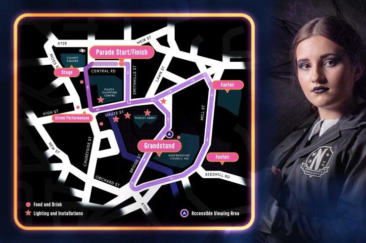
- The journey time to Paisley from Glasgow Central is less than 15 minutes. On arrival at Paisley Gilmour Street, exit via County Square to reach the festival site.
- Plan your journey at www.scotrail.co.uk
Travel by bus
- McGill’s Buses operate several services to Paisley town centre from across Renfrewshire and beyond. Please note that some bus stops and routes may be impacted by road closures.
- Plan your journey at www.mcgillsbuses.co.uk
Travel by car
- Paisley town centre is a 12-minute drive from Glasgow city centre and just minutes away from the M8 motorway exits 27 and 29.
- Car parking is available across Paisley town centre, but please note that some car parks will be impacted by event road closures. If you’re travelling by car, we recommend the following parking locations: Piazza Shopping Centre car park (open until 9pm); Paisley Centre (Horizon) car park; Paisley Grammar School; West College Scotland.
Road closures
Paisley Halloween Festival can be a busy event, with some disruption to traffic and public transport. Please read the guidance below and plan ahead.
The following closures will be in place:
From 12 midnight on 21 October to 5pm on 29 October.
- Bridge Street from Renfrewshire House to Bridge Street car park
- Bridge Street car park
From 12 midnight on 22 October to 12noon on 27 October.
- Lagoon car park
From 10am on 23 October to 11pm on 26 October
- Central Road
From 12 midnight on 24 October to 11pm on 25 October
- Orchard Street car park
From 2pm to 11pm on 24 October and 12pm to 11pm on 25 October
- Smithhills Street
- Gauze Street from Lawn Street to Smithhill Street
- Lawn Street from Silk Street to Gauze Street
- St Mirren Street from Gauze Street to Causeyside Street
- Causeyside Street from Gauze Street to New Street local access
- County Place from Moss Street to Gilmour Street
- Moss Street from School Wynd to High Street
- Orchard Street
- Marshalls Lane
- Gilmour Street
- County Square
- County Place
- Forbes Place
- High Street
From 4 – 11pm on 24 October and again from 4 – 11pm on 25 October
- Gauze Street from Silk Street to Lawn Street
- Abbey Place at Cotton Street
- Cotton Street
From 6 – 9pm on 24 October and again from 6 – 9pm on 25 October
- Gauze Street from Silk Street to Mill Street
- Mill Street from Incle Street to Lonend
- Near side lane closed from Johnston Street to Lonend
- Seedhill Road from Cochrane Street to Mill Street
- Bank Street
Parking on many of the above streets will be suspended from 12 midnight on 24 October to 11pm on 25 October.
Signs will be in place showing alternative bus routes. Please note that some bus stops and routes may be impacted by road closures. Check local operators McGills Buses for more information.